Driving Instructions for
|
This webpage contains driving directions to get to the starting area most frequently used for the monthly Third Saturday Ride of the Ventura County Recumbent group. Instructions are provided for access from the Ventura Freeway (US-101) northbound and southbound. If you'd also like a map with these routes marked, you may click
here. You may also click this link for information about the
Ventura County Recumbent Rides, a series of twice-monthly cycle rides.
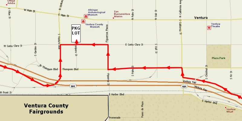
Via US-101 Northbound (from Oxnard, Thousand Oaks, Los Angeles)After you pass the Ventura State Beach on your left, take the next offramp – California Street. Stay in the extreme left lane of the off-ramp, but turn right (north) and then immediately turn left onto Thompson Boulevard. Follow this street as it heads roughly west for about three blocks, then turn right (north) onto Figueroa Street. Go one block and then turn left (west) onto Santa Clara Street. Drive past the small parking lot and grassy area, and then turn right into the large lot for the museum and mission. There is no charge and your vehicle can remain in the lot all day. Public restrooms are available, in the grassy area to the east, and in the museum when it's open. Via US-101 Southbound (from Carpinteria, Santa Barbara)As you enter the downtown Ventura area, immediately after you pass the Ojai Freeway (CA-33) interchange, take the next exit onto Ventura Avenue. You will come off the ramp going north on Ventura; go one block to Santa Clara Street and turn right. It's roughly a short city block to the left turn into the large parking lot for the museum and mission. There is no charge and your vehicle can remain in the lot all day. Public restrooms are available, in the grassy area to the east, and in the museum when it's open. |